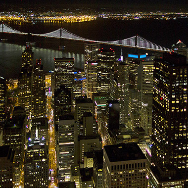
Demolition of Virginia Street Bridge in Downtown Reno, NV
| |

Reno’s Virginia Street Bridge – Demolition Has Started!

Reno’s Virginia Street Bridge – Demolition Has Started! Yesterday’s aerial construction demolition photos of the Virginia Street Bridge, the oldest of all the usable bridges spanning the Truckee River. This 1905 iconic bridge is being replaced after sustaining damage from flooding in 1997 and 2005. The bridge has long been the symbol of divorce folklore –…

Topaz Lake Aerial View
|

Aerials of Topaz Lake in Nevada and California

Aerial Photography View of Topaz Lake Topaz Lake is located on the Nevada (Douglas County) and California (Mono County) border – about a 90 minute drive south of Reno. In this aerial you can see the reservoir’s residential area is on the northwest shore showing boat access to the water. Boating, water-skiing and fishing are…

Haunted Cemetery in Virginia City Aerial View
|

Aerial Haunted View – Nevada’s Comstock Cemetery

The Story of the Glowing Headstone From a distance, witnesses claim to see a headstone glowing at night in the Virginia City cemetery. The ghostly event happens only occasionally, and the glow fades as you approach the light. Many ghost hunters and investigators have tried to solve this mystery by investigating with special permission. You can…

Interesting Google Earth Locations
| |

Interesting Google Earth Images – Nevada

Google Earth Locations To Investigate Nevada has an interesting history with unique sites, some of which can only been seen using Google Earth. Here are some noteworthy images I have found. You will need to open Google Earth and paste the latitude/longitude locations below. Fun Stuff!